

Case studies of watershed-based water balance
/A watershed can be defined as “the topographic area within which apparent surface water runoff drains to a specific point on a stream or to a waterbody such as a lake” (Shimon, 2010), this way a watershed works as a large water collector converting water inputs into runoff and water storage (Chavarri, 2012). Knowing watershed´s hydrological characteristics (precipitation, runoff, evapotranspiration, and groundwater infiltration) allows to evaluate spatial and temporal water resources availability, it is useful for water resources allocation and flow control. Water balance is a tool that allows knowing basin characteristics by application of the mass conservation principle or continuity equation (Rose, 2004; Essam, 2007), according to rhis principle, any difference between inputs and outputs must be reflected in a change in the storage of water within the budget area (UNESCO, 1988; Shimon, 2010).
Inputs = Outputs + Change in storage
P + Si + Gi = So + Go + ET + ΔS

Figure 1: Inputs, Outputs and Changes in Storage of a Watershed.
CASE STUDY: Development of a Watershed-Based Water Balance Tool for Water Supply Alternative Evaluations
This study has been developed at Nookachamps basin, Skagit County in Washington. This basin has a complex water resources management due to two key drivers:
- Population growth and associated water demands.
- Environmental regulations that do not allow water surface use because it is a priority for endangered species of salmon. These regulations limit the water withdrawn from wells. This watershed area, approximately 44,000 acres in size, is heavily forested and rural in nature, with agriculture and commercial forestry dominating the local economy. Nookachamps Creek originates at Lake McMurray, flows through Big Lake, and then ultimately joins the Skagit River (end of the basin). In this basin there are 2 areas with different water resources management.
- Upstream: Mc. Murray Lake is located in this area. It is an area with low population density. Individual ground water wells are relied for water supply, and septic systems are used for wastewater treatment (50 % of this water is lost by evaporation).
- Downstream: in this area is located Big Lake. It is an area more densely populated. Water supply for these areas, which comes from outside of the basin (imported water), and wastewater are collected and conveyed out of the basin for treatment and disposal in the Skagit River outside of the basin.
Objective
Provide a tool to assist decision making and planning on land and water resources management, considering natural and built environments in a long-term by analyzing the positive impact upon water balance of water/wastewater and land use management options.
Methodology
This study evaluates the impacts that the built environment has upon the natural water balance.
Relationships with the overall water balance have been considered like the processes of water being “taken away from” and “imported to” the basin as a result of various water supply and wastewater management options, or the use of ground water wells and septic systems as a net negative impact to the water balance.
To capture a wide range of potential water balance effects, four water/wastewater management options have been considered for analysis, in conjunction with four land use management options. The following figure shows these options and other characteristics of the basin:
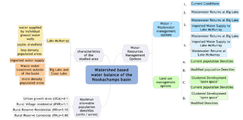
Figure 2: Water Resources Management Options.
Together, these create a total of 16 water resource management options for analysis, but only 8 options have been evaluated in the present study: 1A, 1B, 1C, 1D, 2A, 2B, 2C and 2D.
This analysis was done with the aid of a conceptual model that converts population growth into out of stream water demand and associated waste water flows. This conceptual model has been constructed using a software tool named Community Viz. Figures below show results on annual and summer evaluations respectively.

Figure 3: Annual Impact of Water Resource Management Options upon Water Balance.

Figure 4: Summer Month Impact of Water Resource Management Options upon Water Balance.
The information presented in figures 3 and 4 helps understand the relative effects of various water/wastewater and land use management options, it does not relate these impacts to present levels of flow in Nookachamps Creek, but there is a lack of historical stream flow monitoring data for this basin (only 3 years of record). A cursory analysis indicates that the maximum positive annual water balance impact (almost 400 ac-ft) translates to approximately 0.5 % of the annual average flow volumes (76600 ac-ft).
While on an annual basis, revised water resource management strategies may not impart a significant impact to the basin’s water balance, during low flow summer months, the maximum positive daily water balance impact (almost 1.0 cfs) translates approximately 57 % of the lowflow daily total (1.75 cfs). this analysis makes evident the importance of strategies for land and water management.
Conclusions
The case study did not analyze a complete watershed based water balance because it does not include inputs and outputs as precipitation or inflow of groundwater; neither includes all the water uses like agriculture and commercial forestry; however it was not the objective of study, but analyzing the impact of water resources and land use management options upon water balance of the basin.
The strategies evaluated in this study have the potential of providing a substantial benefit to low-flow period stream flows, thereby supporting the natural environment objectives while sustaining future growth of the built environment.
References
- Anderson R., Hansen J., Kukuk K., Powell B. 2006, Development of a Watershed-based Water Balance tool for Water Supply Alternative Evaluations, Water Environment Foundation.
- Chavarry E. 2012. Métodos de Análisis en Ingeniería de Recursos Hídricos. Universidad Agraria la Molina. Perú.
- Essam M. 2007. Water Flow and Chemical Transport in a Subsurface Drained Watershed, University of Illinois, United States of América.
- Rose Calvin. 2004. An Introduction to the Environmental Physics of Soil, Water and Watersheds, University of Cambridge, United Kingdom.
- Shimon C. 2010. Water Resources. Island Press, United States of America.
- Unesco. 1981. Methods for Water Balance Computation. Instituto de Hidrología de España. España.


