How to direct download / clip elevations and import them to Model Muse with Python - Tutorial

If you work often with numerical models this process will save you much time. The traditional method of downloading elevation models (Aster DEM) from websites, and reprojecting / clipping them with GIS software can be time consuming and pulls you out of other critical tasks on model conceptualization and calibrations. We have done a complete process in Python under WSL that runs Ubuntu in Windows, this platform was chosen due to the complexities of installing GDAL in Windows.

There are two scripts, one to download the images and the second to translate and clip the image. Finally the elevation are imported as a Surfer Grid File (*.grd) into a model in Model Muse.

Read More
Comment


Suscribe to our online newsletter

Subscribe for free newsletter, receive news, interesting facts and dates of our courses in water resources.


3d visualization of Modflow 6 models with Model Viewer - Tutorial

Model Viewer is an excellent option for the visualization and even the animation of MODFLOW models. There is a version of Model Viewer for Modflow 6 models and another for the rest of MODFLOW versions. This tutorial deals with the whole procedure of 3d model visualization that covers the model import, setting up the vertical exaggeration, making isosurfaces, show flow direction arrows, plotting boundary conditions among other features of Model Viewer.

Read More
Comment


Suscribe to our online newsletter

Subscribe for free newsletter, receive news, interesting facts and dates of our courses in water resources.


Spatial data processing for groundwater modeling in Model Muse - Tutorial

Groundwater model creation requires a complete set of spatial data for the different hydraulic parameters, boundary conditions and other model items. Vector and raster data need to be preprocessed, converted, reprojected to fit the requirements of Model Muse.

This tutorial covers an applied case of raster and vector data processing for a groundwater model over the Oahu island (Hawaii, USA). The tutorial covers the steps to download the data, extract the river network and import the spatial data into Model Muse.

Read More
Comment


Suscribe to our online newsletter

Subscribe for free newsletter, receive news, interesting facts and dates of our courses in water resources.


Seawater intrusion modeling with Flopy and Modflow Buy over a Tupac Cloud project - Tutorial

Finally, a complete alternative for the simulation of seawater intrusion on fully geospatial groundwater flow models of coastal aquifers based on open source software. The groundwater flow model was constructed on the Tupac Cloud platform with two stress periods and a total simulation time of 40 years.

The Tupac project is downloaded and run locally on Anaconda where the Buy package for variable density flow together with the transport model are implemented on a Flopy script. A graphical representation of the grid, boundary conditions and results from the flow and transport models are developed as well on the Jupyter notebook.

Read More
Comment


Suscribe to our online newsletter

Subscribe for free newsletter, receive news, interesting facts and dates of our courses in water resources.


Tupac Cloud T.8: Coastal aquifer simulation with wells and rivers on steady and transient states

Applied case of regional groundwater modeling for a coastal aquifer with Modflow 6 using Voronoi meshes on Tupac Cloud. The aquifer has two stress periods (steady state and transient state) of 20 years each that simulate two phases of low/high aquifer exploitation. The model is constructed entirely from zipped shapefiles and rasters on the online platform. Results from the simulation are discussed on the water balances, water table distribution and cross section for all stress periods.

Read More
Comment


Suscribe to our online newsletter

Subscribe for free newsletter, receive news, interesting facts and dates of our courses in water resources.


Tupac Cloud T.7: How to download your Tupac Cloud project and run it locally with Python and Flopy

Tupac Cloud is based on Python and Flopy and every project can be downloaded to your machine for special analysis, furter Modflow 6 feature implementation, machine learning based calibration, or just because a local backup copy is required. This tutorial shows the complete procedure to download a Tupac Cloud project, the executable implementation, the scripts to run the flopy code and well as a description of the different files and folders from a model project.

Read More
Comment


Suscribe to our online newsletter

Subscribe for free newsletter, receive news, interesting facts and dates of our courses in water resources.


Tupac Cloud T.6: Transient simulation of tunnel interaction with the groundwater flow regime

This is an applied example of the impact trough time of a tunnel over the regional groundwater flow regime. The model has 5 stress periods with two variants of the drain (DRN) package implemented in Tupac Cloud. The tutorial covers all steps from model construction, boundary condition setup, model run and output data analysis.

Read More
Comment


Suscribe to our online newsletter

Subscribe for free newsletter, receive news, interesting facts and dates of our courses in water resources.


Tupac Cloud T.5: Groundwater modeling of a construction site dewatering with well and trenches

Applied case for the evaluation of a drainage schema on a construction site with Tupac Cloud. The model has three stress periods where the drainage schema starts with well pumping for 10 days and trench drainage with pumping for another 10 days. Results from the water balance were analyzed as well as the final distribution of head on the proposed construction site.

Read More
Comment


Suscribe to our online newsletter

Subscribe for free newsletter, receive news, interesting facts and dates of our courses in water resources.


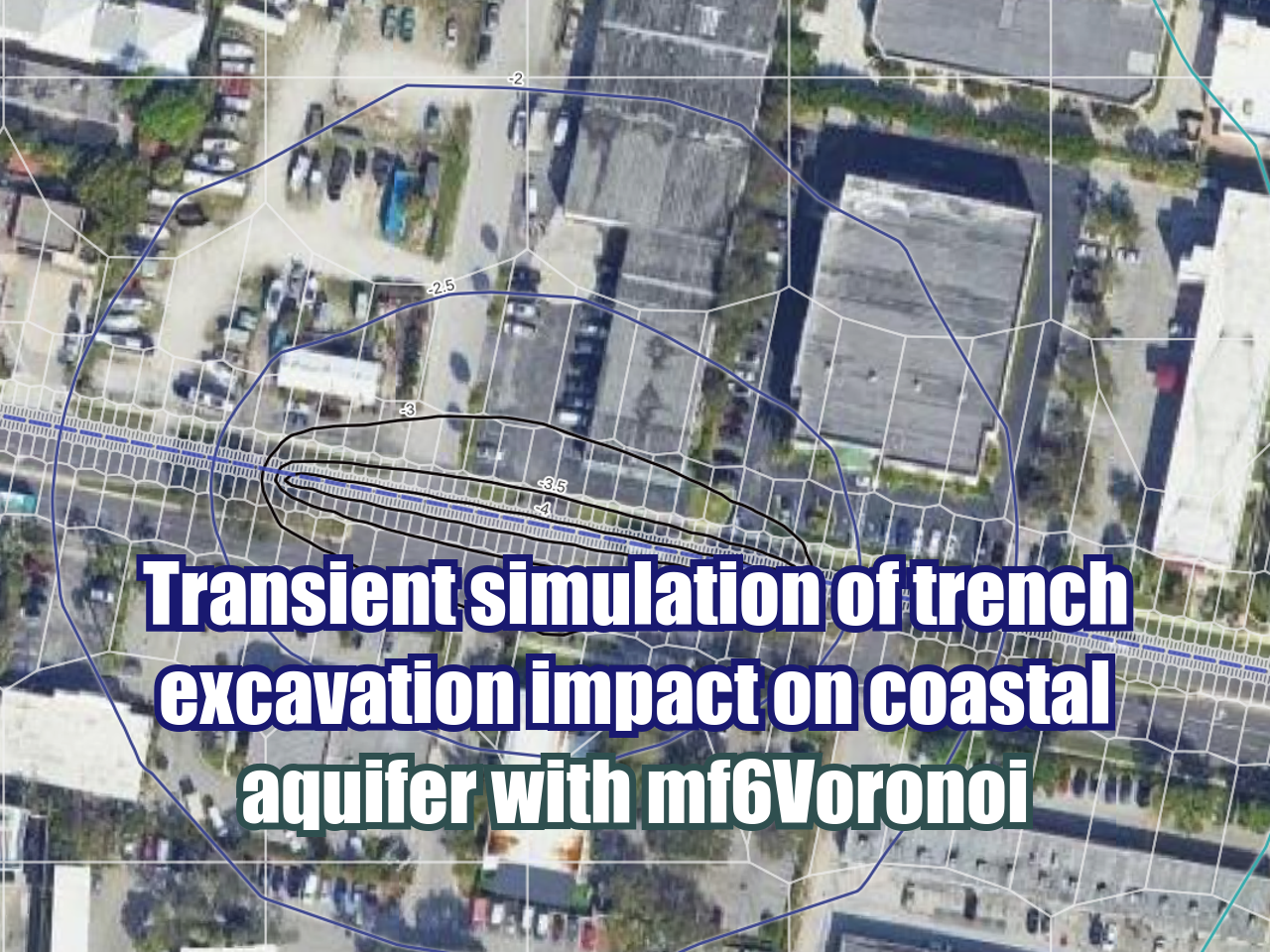
Tupac Cloud T.4: Transient simulation of the trench excavation impact on a coastal aquifer

Local scale modeling of a 4 stage trench excavation on a coastal aquifer. The main objective of this modeling work is assessing the impact of the excavation on the nearby groundwater flow regime. The modeling work was done entirely with the tools, charts and tables from Tupac Cloud.

Read More
Comment


Suscribe to our online newsletter

Subscribe for free newsletter, receive news, interesting facts and dates of our courses in water resources.


Tupac Cloud Beta Tutorial 3: 3D voronoi model mesh generation as Vtk

From the latest developments in our codes, MF6 and Flopy we have created tools in Tupac Cloud for 3d mesh generation as Vtk files. This is an applied example of this functionality based on a dataset for river - aquifer interaction where the resulting Vtk are plotted on Paraview.

Read More
Comment


Suscribe to our online newsletter

Subscribe for free newsletter, receive news, interesting facts and dates of our courses in water resources.


Introducing Tupac Cloud: An online tool for groundwater modeling

Tupac Cloud is our developing online groundwater modeling platform. Models on Tupac Cloud are based on Voronoi meshes and constructed in MODFLOW 6 DISV from Flopy scripts. The whole project will have lot of tools and integrations with QGIS and Paraview, this is just an example of mesh generation for an applied case of river aquifer interaction.

Read More
Comment


Suscribe to our online newsletter

Subscribe for free newsletter, receive news, interesting facts and dates of our courses in water resources.


How to create quadtree refinements for MODFLOW 6 models from multiple shapefiles - Tutorials

Quadtree refinements are available for Modflow 6 models in the latest versions of Model Muse. This tool can be inplemented for many spatial objects as points, lines or polygons where you can specify the refinement level for each layer separately. We have done an applied case of mesh refinement of a regional model where the river network, observation points and tunnel aligment were defined as refinement objects.

Read More
Comment


Suscribe to our online newsletter

Subscribe for free newsletter, receive news, interesting facts and dates of our courses in water resources.


3D visualization of voronoi gridded models with Model Viewer for Modflow 6 - Tutorial

Model Viewer for Modflow 6 was launched in April 2022 and it is a version of Model Viewer customized to display the features, grid and results of MODFLOW 6 models. We have done an applied case for the visualization of a MODFLOW 6 DISV model that has a voronoi mesh. The tutorial covers the steps to visualize the model grid lines, grid shell, isosurfaces, color grid, flow directions among other visualization options.

Read More
Comment


Suscribe to our online newsletter

Subscribe for free newsletter, receive news, interesting facts and dates of our courses in water resources.


Interactive cross section generator for a voronoi gridded Modflow 6 model - Tutorial

We are allways on the research of new visualization tools for groundwater models and that would imply the review of different apis, codes and backends. This time we have done an applied example for the interactive generation of cross section from a Modflow 6 model with a voronoi mesh on a Jupyter notebook. The cross section shows the model grid, head distribution as a color grid and contours and its generated from the line delineation over the 2d view of the model grid. The code can be easily adapted to any Modflow model by editing the Python and Flopy code.

Read More
Comment


Suscribe to our online newsletter

Subscribe for free newsletter, receive news, interesting facts and dates of our courses in water resources.


Regional groundwater Modflow 6 model with Voronoi Mesh - Tutorial

We have developed a version of our Angascancha basin case study that runs on MODFLOW 6 with discretized by vertices (DISV). The model implements a Voronoi mesh that is generated from the basin boundary and river network and the refinement levels are defined by a minimum and maximum cell size together with determined refinement steps. The tutorial is complete in all the steps involving the model discretization, construction, simulation and visualization.

Read More
Comment


Suscribe to our online newsletter

Subscribe for free newsletter, receive news, interesting facts and dates of our courses in water resources.


River-Well-Aquifer Geospatial Groundwater Flow Model with Voronoi Mesh - Tutorial

This is an applied example of a fully geospatial groundwater flow model with the MODFLOW 6 Disv discretized by vertices option. Model was constructed with Python and Flopy from a series of shapefiles and it has a progressive refinement for well and river boundary conditions. Regional flow has been simulated as a General Head Boundary and plotting options were developed for the grid and model output representation on areal view and cross section.

Read More
Comment


Suscribe to our online newsletter

Subscribe for free newsletter, receive news, interesting facts and dates of our courses in water resources.


New website! MODFLOW Questions and Answers: ask anything on groundwater modeling

Until now we had limited options to provide specific support in groundwater modeling. We know that modeling requires the review of extensive documentation and practical work with the software and sometimes or most times we don't have the time to sort things out.

Read More
3 Comments


Suscribe to our online newsletter

Subscribe for free newsletter, receive news, interesting facts and dates of our courses in water resources.


Example of Seawater Intrusion Modeling with Modflow 6, Model Muse and Flopy - Tutorial

MODFLOW 6 implements the Buoyancy package for the simulation of variable density and seawater intrusion cases. The tools are implemented in the Python package Flopy, however the workflow has changed substantially from the previous models of flow and transport. We have developed an applied case seawater intrusion model on a regular geometry model constructed with Model Muse for flow and Flopy for transport.

Read More
Comment


Suscribe to our online newsletter

Subscribe for free newsletter, receive news, interesting facts and dates of our courses in water resources.


What to do when your MODFLOW MT3D contaminant plume doesn’t migrate?

This is a problem that every hydrogeologist - numerical modeler has faced many times over his/her professional career independently from the theoretical background and skills with the code, graphical user interface or Python library.

We don’t know why groundwater “flows” and a contaminant plume “migrates” when both move on the aquifer system. After you construct you model geometry, setup the flow boundary condition, specify your transport package, define your contaminant sources, run your MODFLOW flow model and then run your MT3D model (or even your MT3DMS model) you will find that there is no plume, none, nada, nichts.

Read More
Comment


Suscribe to our online newsletter

Subscribe for free newsletter, receive news, interesting facts and dates of our courses in water resources.


Is glTF an alternative to VTK for the representation of voronoi mesh Modflow6 models?

Representation of geospatial objects in 2D are well covered by the GIS software and standards where we have powerful tools and interchangeable spatial files, however when we work on 3D objects the universe of software and tools is like a jungle with a wide variety of issues. We will always consider 3D as the ultimate representation of an object using a computer, by sure the holograms and augmented reality can improve the way we interact with a object geometry, but since we are not in the common near future we will give much effort to the representation of these objects in our computer screens, tables and cellphones.

Read More
Comment


Suscribe to our online newsletter

Subscribe for free newsletter, receive news, interesting facts and dates of our courses in water resources.