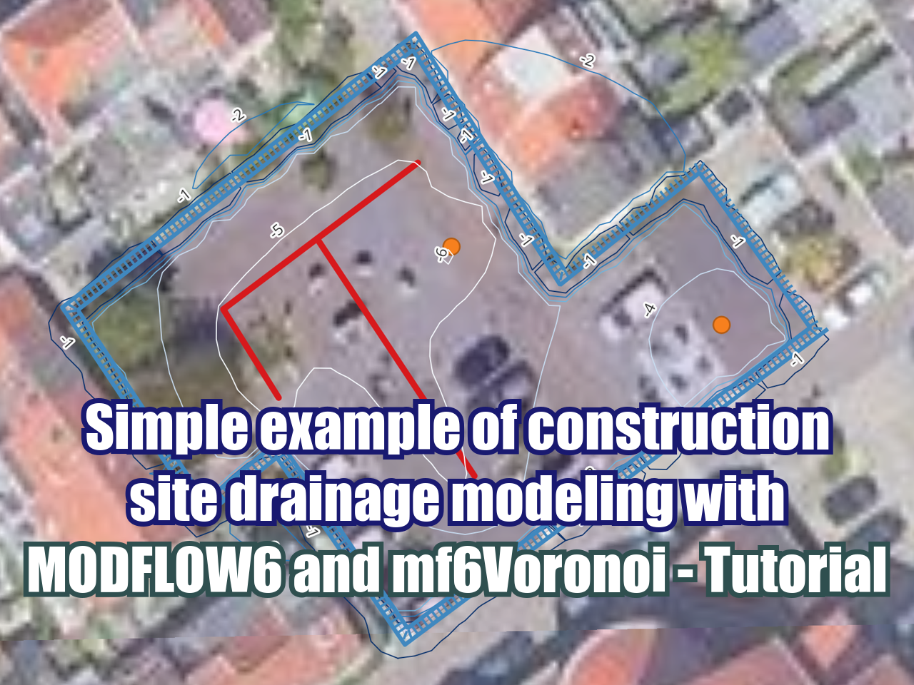
Simulation of Radial Drains for Tailings Drainage with MODFLOW Tutorial

MODFLOW is a versatil and applied computer code written in Fortran capable of modeling groundwater flow on steady and transient conditions. MODFLOW can simulate a diverse sort of groundwater flow management cases due to its packages and solvers. This tutorial shows the application of MODFLOW for the simulation of radial drains in a mine tailings facility. The simulation considers 16 drains of 60 m length over a simulation period of 1000 days.

Read More


Suscribe to our online newsletter

Subscribe for free newsletter, receive news, interesting facts and dates of our courses in water resources.


Aqueous species in water speciation calculation with Phreeqc tutorial

This example calculates the distribution of aqueous species in seawater and the saturation state of seawater relative to a set of minerals. To demonstrate how to expand the model to new elements, uranium is added to the aqueous model defined by phreeqc.dat.

Read More


Suscribe to our online newsletter

Subscribe for free newsletter, receive news, interesting facts and dates of our courses in water resources.


How to install Phreeqc on Notepad++

PHREEQC version 3 is a computer program written in the C and C++ programming languages that is designed to perform a wide variety of aqueous geochemical calculations. PHREEQC implements several types of aqueous models: two ion-association aqueous models (the Lawrence Livermore National Laboratory model and WATEQ4F), a Pitzer specific-ion-interaction aqueous model, and the SIT (Specific ion Interaction Theory) aqueous model. Using any of these aqueous models, PHREEQC has capabilities for (1) speciation and saturation-index calculations; (2) batch-reaction and one-dimensional (1D) transport calculations with reversible and irreversible reactions.

Read More


Suscribe to our online newsletter

Subscribe for free newsletter, receive news, interesting facts and dates of our courses in water resources.


Key concepts to become a numerical modeler

Nowadays, water resources management requires a better understanding of nature and a superior evaluation of the impacts caused by humans. We are concerned and focused on sustainability because we live on a planet with limited resources and changing environments. In some way, we know that the actual changes are results from past and present actions along with the effect of nature cycles.

Read More


Suscribe to our online newsletter

Subscribe for free newsletter, receive news, interesting facts and dates of our courses in water resources.


Simulation Tutorial of Heavy Metals Bioaccumulation at Wetlands with MODFLOW-MT3DMS

If we want to talk about concentrations, solutes and contaminant transport in groundwater, we need to mention the Source/Sink concepts and natural concentrations in groundwater. Sources represent solute mass entering the system, which could be representing spills or natural lixiviation processes. Sinks are the zones where water with solute concentrations leave the system.

Read More


Suscribe to our online newsletter

Subscribe for free newsletter, receive news, interesting facts and dates of our courses in water resources.


Regional precipitation analysis with Python

We want to analyze average annual precipitation data on a regional scale for the North of Peru. The dataset has 20 stations from the Peruvian desert coast, Andes and rainforest with differences in elevation and precipitation rates.

The main objective is to analyze precipitation patterns and trends by plotting them in different ways using Python.

For this task we use IPython Notebook, which you can install on your own computer or run it on the cloud from wakari.io. You can download the station data for this exercise here

Read More


Suscribe to our online newsletter

Subscribe for free newsletter, receive news, interesting facts and dates of our courses in water resources.


Tailing and waste dump seepage evaluation and remediation

Current and historical mining activities have a seepage and waste-dumps legacy that are the concern for mining companies, population and regulatory authorities.

Old waste-dumps have not been regulated and most of the old tailings have been deposited in soils without covering. Tailing deposits and waste-dumps should be analyzed in a particular way because of the ground, instalation details, mineralized body geology, mined type, weather and other parameters.

Recent mining activities count with major engineering in waste-dumps and tailing deposit instalations, as well as better monitoring evaluation seepage. However, there is still a seepage risk coming from old and new waste-dumps and their transport constituties a potential environmental issue.

Read More


Suscribe to our online newsletter

Subscribe for free newsletter, receive news, interesting facts and dates of our courses in water resources.


Questions on MODFLOW with Model Muse

Some questions from a follower:

Thanks for agreeing to help. I developed a simple mode just to check if it works. But I get this error (attached). There are NO streams in my study area so do I still need to give my model a input for drainage package? I wanted to go around it but I could not proceed, therefore I created streams as drainage lines from DEM.

Read More


Suscribe to our online newsletter

Subscribe for free newsletter, receive news, interesting facts and dates of our courses in water resources.


Design and implementation of groundwater monitoring systems

A monitoring network is a system where the level and quality records that the groundwater describes are generated, become available and are evaluated. These records are consistent, representative and long lasting.

Read More


Suscribe to our online newsletter

Subscribe for free newsletter, receive news, interesting facts and dates of our courses in water resources.


Environmental flow determination by hidrological modeling

The world water legislation has a common challenge: distribute fresh water resources in a fair, efficient and sustainable way. Traditionally, agriculture, industry, mining and municipalities have competed for these limited resources.

Read More


Suscribe to our online newsletter

Subscribe for free newsletter, receive news, interesting facts and dates of our courses in water resources.


Climate change impact on watershed response

Mathematical models of global climate can reproduce many aspects of the physical climate system. General Circulation Models (GCMs) simulate physical processes in the atmosphere, ocean, cryosphere, and on land surface. Predictive scenarios on climate change will be applied to selected GCM models and their output will be used on the PRMS hydrologic simulations.

Read More


Suscribe to our online newsletter

Subscribe for free newsletter, receive news, interesting facts and dates of our courses in water resources.


Development of a watershed-based water balance

Water balance is known as the balance of water entering the system and the water that leaves within a specified time, but to understand it better we need to understand: what is a watershed? Unterstood as a whole, a unity, as a system, as the space bounded by the union of all the headers that form the main river through the territory drained by a single natural drainage system.

Read More


Suscribe to our online newsletter

Subscribe for free newsletter, receive news, interesting facts and dates of our courses in water resources.


Case studies of watershed-based water balance

A watershed can be defined as “the topographic area within which apparent surface water runoff drains to a specific point on a stream or to a waterbody such as a lake” (Shimon, 2010), this way a watershed works as a large water collector converting water inputs into runoff and water storage (Chavarri, 2012). Knowing watershed´s hydrological characteristics (precipitation, runoff, evapotranspiration, and groundwater infiltration) allows to evaluate spatial and temporal water resources availability, it is useful for water resources allocation and flow control. Water balance is a tool that allows knowing basin characteristics by application of the mass conservation principle or continuity equation (Rose, 2004; Essam, 2007), according to rhis principle, any difference between inputs and outputs must be reflected in a change in the storage of water within the budget area (UNESCO, 1988; Shimon, 2010).

Read More


Suscribe to our online newsletter

Subscribe for free newsletter, receive news, interesting facts and dates of our courses in water resources.


Why consultants, mines and organizations should migrate to QGIS?

This question has been popular for the last three or four years. I have been using Quantum GIS (QGIS) from version 0.8, and now QGIS is on version 2.4.

Read More


Suscribe to our online newsletter

Subscribe for free newsletter, receive news, interesting facts and dates of our courses in water resources.


How to apply styles to rasters in GIS?

Tutorial about how to apply styles in QGIS.

Read More


Suscribe to our online newsletter

Subscribe for free newsletter, receive news, interesting facts and dates of our courses in water resources.


Tutorial to do a cross section with QGIS

Simple tutorial about cross seccions with the Profile Tool plugin on QGIS.

Read More


Suscribe to our online newsletter

Subscribe for free newsletter, receive news, interesting facts and dates of our courses in water resources.


Some questions of data visualization in Model Muse

Hi Saul, I am Giuseppe and I watched your lessons on ModelMuse on YouTube. I’m trying to learn how to use that software, maybe you can help me if you have time.

Read More


Suscribe to our online newsletter

Subscribe for free newsletter, receive news, interesting facts and dates of our courses in water resources.


Installation Guide for OpenFoam 2.3.0 on Ubuntu 14.04

Installation Guide for OpenFoam 2.3.0 on Ubuntu 14.04

Read More


Suscribe to our online newsletter

Subscribe for free newsletter, receive news, interesting facts and dates of our courses in water resources.


MOD16 for actual evapotranspiration measurement

This project is part of NASA/EOS project to estimate global terrestrial evapotranspiration from earth land surface by using satellite remote sensing data. MOD16 global evapotranspiration product can be used to calculate regional water and energy balance, soil water status; hence, it provides key information for water resource management.

Read More


Suscribe to our online newsletter

Subscribe for free newsletter, receive news, interesting facts and dates of our courses in water resources.


Feflow or Modflow? A recurrent question

Once again I had a crush with the question whether Feflow or Modflow. I think this question is related to how bad are we selling environmental services and environmental software.

It is a matter of faith

Read More


Suscribe to our online newsletter

Subscribe for free newsletter, receive news, interesting facts and dates of our courses in water resources.