

VIDEO: Webminar on Groundwater Modeling with MODFLOW and Model Muse - May, 15 2017
/In case you missed or want to see again our webminar streamed on May 15th, 2017 , here you can find the recorded video.
Read MoreIn case you missed or want to see again our webminar streamed on May 15th, 2017 , here you can find the recorded video.
Read MoreWebOpenDroneMap is a friendly Graphical User Interfase (GUI) of OpenDroneMap. It enhances the capabilities of OpenDroneMap by providing a easy tool for processing drone imagery with bottoms, process status bars, and a new way to store images. WebODM allows to work by projects, so the user can create different projects and process the related images.
As a whole, WebODM in Windows is a implementation of PostgresSQL, Node, Django and OpenDroneMap and Docker. The software instalation requires 6gb of disk space plus Docker. It seem huge but it is the only way to process drone imagery in Windows using just open source software. We definitely see a huge potential of WebODM for the image processing, therefore we have done this tutorial for the installation and we will post more tutorial for the application of WebODM with drone images.
Read MoreSatellite Imagery has developed a new dimension in the evaluation of water resources, environment, land planning, atmosphere and climate change. There are many satellites and imagery available, many of them being free of cost. At the same time, powerful open source tools for spatial analysis and representation are available.
This webminar wants to give a perspective on search, manage and interpretation of satellite imagery, through practical exercises using QGIS.
Read MoreHEC-RAS 5.0 now has a user interface that includes the RAS Mapper, which is used for 2D modeling. It is also possible to see the results in an interactive way.
Here we will present the steps and needed considerations to model river/channel flow in HEC-RAS. This example consists on a water channel that overflows. Referential parameters will be used.
Read More
HEC-RAS is a software developed by the U.S. Army Corps of Engineers for the simulation of superficial flow and has applications for hydraulic design, floods, sediment transport and water quality.
This tutorial will show how to use the new features of HEC-RAS regarding 2D flood modeling. It will start with the importing of a DEM, grid and boundary conditions conceptualization and the configuration of simulation.
1. Open HEC-RAS
2. In the main window, select File > Create new project. Give a name for the project and click OK.

3. You will be asked about the units system. In this case we will use SI Units. Click Accept.

4. Choose the the RAS Mapper icon as shown below:

5. In the RAS Mapper window, right click on Terrain > Create a new terrain.

6. You will be asked about setting the Spatial Reference System. In this case we will select No.

7. Click on the "+" icon and select the DEM. In this case we have the Mashhad-DEM_cut.tif. After selecting the file, you will be asked if you want to use its spatial reference projection for this model. Click Yes.


8. Click Create and wait.

9. Exit the RAS Mapper and select Edit > Geometric Data on the main HEC-RAS window.

10. In the Geometric Data window we will see the DEM we previously uploaded. Select the 2D Flow Area and draw a polygon similar to the one shown below, it will define the area of the model. When you are finished drawing, you will be asked to enter a name for the 2D Flow Area.

11. Select the SA/2D Area BC lines option. Draw the first boundary condition, which will correspond to the Upstream of the river, and then the Downstream boundary condition as shown in the following image. After finishing drawing each one of them, you will be asked to give it name.

12. Select the area, right click and click Edit 2D Flow Area.

13. In the following window, click on the option Generate Computation Points on Regular Interval with All Breaklines. Change the Spacing DX and DY to 20 and then click Generate points in 2D flow area. Finally, click Force mesh recomputation.


14. To save this Geometry: File > Save geometry Data As.
15. In the main HEC-RAS window, go to Edit > Unsteady Flow Data.

16. Here, we have to associate Boundary Conditions types. For the Downstream BC choose Normal Depth and a Friction Slope of 0.02.

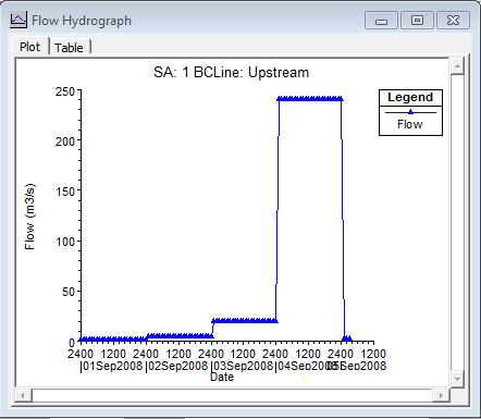
17. For the Upstream BC choose Flow Hydrograph. For this example, the simulation will start on 01 Sept 2008 at 00:00. The flow considered for 01 Sept. is 1 m3/s, 4 m3/s for 02 Sept., 20 m3/s for 03 Sept., 240 m3/s for 04 Sept. and 2 for 05 Sept. Fill all the data required.

18. In the Unsteady Flow Data window, go to File > Save Unsteady Flow Data.

19. In the HEC-RAS main window, select Run > Unsteady Flow Analysis. Select the options as shown here, and click Compute.


20. Finally, to access the results, go to the RAS Mapper and activate the results you want to visualize, like Depht, Velocity or WSE. You can click the Play button and see how the values vary with time.

Download the files here.
Tutorial to install the Docker environment on Windows.
Read MoreThe Hydrologic Engineering Center’s Reservoir System Simulation (HEC-ResSim) is used to model the operations of one or more water reservoirs. This software has many applications, such as:
HEC-ResSim 3.1 has three modules, which give access to directories and specific data of the current Configuration. Here, we will describe the characteristics of the Watershed Setup module.
Read MoreIn this tutorial we will show you how to create a watershed configuration in HEC-ResSim 3.1.
Read MoreA new and fresh opensource preprocessing and post processing tool is available. Freewat 0.4 was launched as a beta version and publicly available upon registration from this website: http://freewat.eu/. Most of the developers are italian and the project is funded under the H2020 program from the European Union and the Regione Toscana. The software comes with clear and descriptive documentation and tutorials plus the installation instructions.
This article show the most important features of Freewat and its capabilities for representing the geospatially referenced regional groundwater flow.
You have finished your undergraduate/postgraduate studies in water resources and want to make a good research thesis? If this is the case, you have several alternatives: research about groundwater, superficial water, floods, inundation areas, flow/ecosystem interaction, even water supply systems. All these areas have specific applied software to evaluate and simulate the actual and future water requirements.
Read MoreThe Water Information Network System is an open source and open access platform that combines geolocalized data.
Read MoreConstructing and calibrating numerical models can be a challenging task in terms of time, available data and professional abilities of the modeler. Since this work is usually done alone, there are many questions about the conceptualization of the physical environment, the construction of the model and the calibration with observed data. Based on the questions asked by some attendees of our webminars, we have written this article for all the confused hydrogeological modelers.
Read MoreFor most hydrogeologists numerical modeling of groundwater flow is still new and brings several challenges when dealing with input data, model construction and simulation. Most of our modeling efforts are done in gravity driven groundwater flow on shallow aquifers solved by Darcy law equations. Sometimes we excel ourselves in conceptualizing "advanced" topics as unsaturated flow, contaminant transport, variable density or baseflow calibration. What about if we consider another driving force besides gravity? Will out lives be happier/miserable? Could we cope with the huge amount of required data?
Read MoreAt some point of you life, you may have come with the idea of starting your own environmental consulting firm. This article can help you to make your project real or, if it is not, you will know it in a short time.
Read MoreIn this opportunity we will present the best scientific articles to learn about the OpenFOAM capacities in the coastal engineering field.
Read MoreIn this tutorial we will show you how to install QSWAT, QGIS interface for SWAT.
Read MoreOver the past few years, environmental technology has improved and become very accessible to the final consumers. It is possible to find environmental sensors at a low cost which can be connected to low cost microprocessors like Raspberry Pi. Raspberry Pi has the capacity to monitor with readings over a long period of time and save them online.
Read MoreSWAT is an open source model that can be used with GIS data to simulate hydrological processes in basins. The SWAT complement is a tool to evaluate soil and water and basin management. The QGIS interface is called QSWAT. The latest version is QSWAT 1.4 which was released on Feb. 2, 2017.
Read MoreEvapotranspiration is the mixed process of soil evaporation and transpiration of plants. This process is not included in many Hydrology books or in hydrological methods like the rational method, SCS, among others. Evapotranspiration is not relevant in when calculating maximum floods, but it is considered in water balances of superficial water and groundwater.
This article shows the relevance of the evapotranspiration process in the conceptualization and modeling of groundwater, indicating which would be the errors and inaccuracies of not considering this process.
Read More
ONLINE COURSES:
LATEST POSTS
SEARCH


 |
 |
 |
 |
 |
 |


